
Frost and Fairfax History (Part 1)
A Journey Back: Pre-history to 1860
The land that would become the site of Frost Middle School has a long and fascinating history. Join us as we take a look back and trace the owners of the land that would eventually become Frost Middle School and Woodson High School.
"...the possession of land quickly came to dominate the economic, social, and political life of the colony. Thus, the early history of northern Virginia, when the area now encompassed by Fairfax County progressed from frontier to plantations and small farms, is deeply rooted in the land." - Robert Moxham, Fairfax historian
Powhatan, Lord Fairfax and Colonial Life
- Before the United States became a country, this entire area was part of the British colony of Virginia, founded in 1607 by John Smith. Smith explored and mapped our area in 1608, writing detailed accounts in journals and drawing maps. Trees covered the land and Native American trails criss-crossed the area between native villages and gathering places.
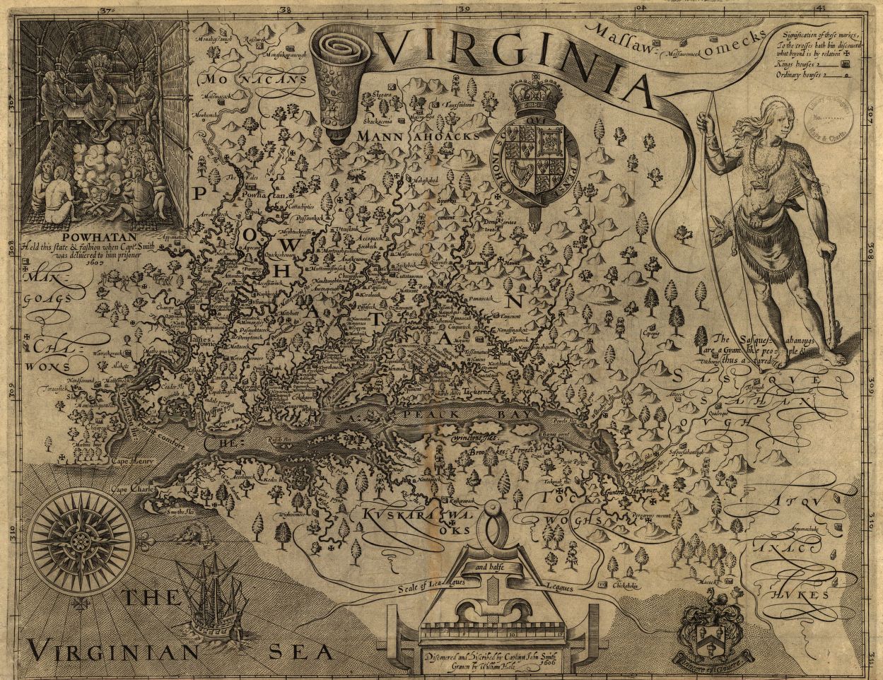
- Powhatan was a powerful man among his people, the supreme chief of almost 30 Algonquin tribes whose territory ranged from the James River north to throughout the Chesapeake Bay area. John Smith estimated that the native tribes had established over 150 towns and a network of trails. The Native Americans did not have the concept of "owned land" or land for exclusive use of one person or a small group of people. They believed the land belonged to everyone. Therefore the European idea of owning or claiming land meant nothing to them, although it meant everything to the Europeans.The European settlers brought trade and for a time, the two groups co-existed on the land, sharing ideas such as farming techniques and map-making. But Europeans also brought unfamiliar diseases and more settlers were arriving every year. Over time, the European settlers forced the Native Americans west.
- In 1649, Alexandria and Fairfax County were part of the largest land grant in America, called the Fairfax Grant. The Virginia lands, claimed by the British crown and outlined by the grant, were legally given under English law by the King of England Charles II to his loyal supporter, Thomas Culpeper. The Fairfax Grant was originally 5.2 million acres.
- A generation later, the now-called Northern Neck Grant all belonged to another man, Thomas, 6th Lord of Fairfax, Baron Cameron. His father had married Thomas Culpeper's daughter and only heir in 1690. Upon his father's death, their teenage son, Thomas, now inherited all the lands between the Chesapeake Bay to the banks of the Rappahannok and the Potomac Rivers.
- A Scottish peer and mentor to George Washington, Lord Fairfax gave Washington his first job as a surveyor when Washington was 17 years old. Lord Fairfax is the only British nobleman to have moved to the colonies and lived permanently on his colonial land. Although he was respected by the colonialists as a friend of Washington, during the Revolutionary War, all of his lands were confiscated. He died in 1781, less than two months after the British defeat at Yorktown.
|
VIEW THE MAP that John Smith made of northern Virginia in 1608. READ MORE about what he saw on his trip and the observations he made of Native American life at the time. READ MORE about Powhatan, his territory and what the Chesapeake Bay was like in his time. VIEW PICTURES AND MAPS of the Fairfax and Northern Neck Grants. Find out why King Charles II gave all of this land to Thomas Culpeper and why Lord Fairfax decided to move here from England. |
Truro Parish, George Washington and George Mason
- The official religion of the Virginia Colony was the Church of England, so local government In the Virginia colony was administrated for the most part through the Anglican parish. A parish each had a minister and twelve vestrymen, men of education and good standing in the parish. So in the years before Fairfax broke off from Prince William County to become its own county, the vestry of Truro Parish handled local matters.
- Duties of the vestry included the overseeing of building and road construction, determining land ownership and land and property borders, caring for the poor, and arbitrating business and personal disputes. The currency used to pay for all work and services for the parish was, not money, but tobacco.
- George Washington and George Mason were elected multiple times to be vestrymen of Truro Parish. As the two most respected men in the county and large land-owners, their opinions persuaded others. George Mason's writings were the basis of most of Virginia's founding documents, and as a result the U.S. Constitution and Bill of Rights as well. Although for health reasons he rarely left his home at Gunston Hall and declined to be a member of the Constitutional Convention, he is the man most singly responsible for its ideas. George Washington, even while President of the United States, was often seen riding his horse alone through Fairfax County, travelling from D.C. to his home at Mount Vernon.
- The Falls Church and the Pohick Church, both still standing today, were two of the main churches for Truro Parish. When Fairfax County was established, county government took over the governing of the new county from the parish. The parish system was dissolved by 1786.
- Fairfax County was founded in 1742 and in that time included what is now Alexandria, Arlington, Fairfax and Loudoun. The city of Alexandria, already a popular trading area, was established in 1749 and, with its tobacco warehouses all along the Potomac, became one of the busiest ports in the colonies.
|
READ THE PRESERVED HISTORY of Truro Parish archived at Pohick Church where George Washington visited every Sunday. Summarized here, Pohick Church has all of the original Truro meeting records from 1732 to 1785, digitized in high resolution by the Library of Congress. READ MORE about the city of Alexandria, from its time as a Native American settlement to now. LEARN MORE about George Mason, his home at Gunston Hall and the Mason Neck nature preserve nearby where bald eagles live. VISIT George Washington's home at Mount Vernon, just a short horse ride from Alexandria. EXAMINE A PHOTO taken of the Falls Church in 1861 from the Library of Congress collection. |
The Fitzhughs and Ravensworth
- When President George Washington chose the site across the Potomac from Alexandria to become the nation's capital in 1790, the new city of Washington D.C. fueled commerce in the area. Settlements spread inland and westward. The land was mostly made up of large tracts owned by the wealthy, which were farmed as tobacco plantations and worked by white tenant farmers and by black slaves. Transportation of tobacco required the use of waterways, so roads in this time were little more than wide paths leading only to frequent destinations like warehouses, taverns or estate houses.
- In these early days of the country, citizens of Fairfax complained about area road conditions, much as we do now! In 1804, Thomas Jefferson wrote to his friend Nicholas Fitzhugh. Frustrated at the conditions of the main roads on his route from D.C. to his home at Monticello which, due to high use or weather were often impassable, Jefferson asked his friend to draw him a map of back roads to use as an alternate route through what is now the Falls Church/Annandale area. Many of the paths and lanes noted on Fitzhugh's map reflect current roads today.
- Jefferson's friend Nicholas Fitzhugh was the great-grandson of William Fitzhugh, an immigrant and successful lawyer. In 1685, William Fitzhugh bought a 21,996-acre, the largest colonial landgrant in Fairfax County, from Lord Fairfax's father-in-law, then-Governor Thomas Culpeper. Buying the land was a gamble because there was not much there at the time, but land in Fairfax quickly rose in value, and it paid off for the Fitzhugh family.
- William Fitzhugh's land was eventually called Ravensworth Plantation. Three grand estate houses were built on the Ravensworth land, Ravensworth Mansion (now the site of Ravensworth Shopping Center), Ossian Hall (now the Annandale High School neighborhood), and Oak Hill. Oak Hill, home of Nicholas Fitzhugh and visited by George Washington, Lafayette, Thomas Jefferson and other notables, still stands and is a private residence in the Canterbury Woods neighborhood adjacent to Wakefield Chapel Road. The house is open to the public once a year in the fall on Oak Hill Day. Over generations, this great fortune in land called Ravensworth would be divided between William Fitzhugh's descendants, broken up and sold, and eventually Frost Middle School would be built on a piece of it.
- In 1783, Jefferson's friend, Nicholas Fitzhugh inherited "Parcel 1.1.6" upon his father's death. His siblings also inherited other pieces of the Ravensworth land. A 1792 survey show that tenant farmers were renting and farming what is now the Frost/Woodson land.
- In 1813, Nicholas Fitzhugh divided his parcel and sold 98 acres of it (Parcel 1.1.6.4) to Gerard Huntt for $783.
|
READ MORE about Lord Fairfax and the millions of acres of his land that later became Northern Virginia. VIEW THE MAP of Lord Fairfax's land, surveyed in 1736. READ Thomas Jefferson's letter about roads in Fairfax County. See the map drawn for Jefferson by Nicholas Fitzhugh and compare it to a map of the area today. SEE A PHOTO SLIDESHOW of Ossian Hall before it was burned on purpose by the FCFD in 1959. Nicholas Fitzhugh originally lived here with his family of 12 children. READ MORE about the Fitzhugh family and the great estate of Ravensworth. SEE AERIAL PHOTOS of Oak Hill in 1966 during construction of Canterbury Woods and the NOVA Annandale Campus. FIND OUT from the Braceland family what it's like to live in a historical home. |
Little River Turnpike
- By the 1800's, as land owners began to realize that tobacco wore out the soil, they started farming other products. These new goods needed to be transported over land. Land-owners, farmers and local governments alike recognized that good roads would be necessary for the region's economic success. Roads were few though. The most prominent roads were the Potomac Path (later Route 1), the Middle Road (later Leesburg Pike/Route 7), and the Alexandria-Centreville Road (later Braddock Road).
- A new wider road was needed to go from the port of Alexandria through the fertile farm lands of Fairfax County to carry goods west. Plans were made for the road to take the straightest path from Alexandria through the Ravensworth lands, connecting the towns of Annandale and Providence to points west. From Providence, the road followed the path of today's Route 50 to the Aldie Mill on the banks of the Little River in the village of Aldie, home of James Monroe.
- In 1800, the town of Providence, later named Fairfax City in 1874, had become the site of the fourth Fairfax County Courthouse due to its central location in the county. In fact, in most documents of the time, the town is referred to as "Fairfax Court House" and rarely is the term "Providence" used.
- The problem was how to pay for the new road. In 1801, a private company was formed to sell stock to pay for the construction of the road. Later, after the road was finished, the plan was to charge users of the road a toll. The money would be used for the upkeep of the road. Little River Turnpike became the third toll road in America and the first privately owned toll road. This system is a lot like the Hot Lanes we use on our local highways today!
- By 1811, the entire 34 miles of the road was complete. Toll houses were placed along the road to collect tolls. The nearest toll to Frost was in Annandale where the road intersects with Ravensworth Road. Once a traveller had paid the toll, the fence blocking the road would be "turned" by wheel to allow them through, hence the name "turnpike".
- Tolls were collected for almost 100 years on Little River Turnpike until 1896 when Fairfax County took over maintenance of the road. In 1932, the Virginia General Assembly passed state maintenance of secondary roads, giving responsibility of road upkeep to what is now VDOT (Virginia Department of Transportation). As roads took on more and more traffic through the years, the state would use the rule of "eminent domain" to seize land on either side of roads from their owners so the road could be improved and widened.
- Through the years, Little River Turnpike would continue to connect central Fairfax County from east to west, contributing to commerce and the economic prosperity of the region by allowing farmers and merchants to move their goods from farms to mills to Washington D.C and Alexandria.
|
WATCH A VIDEO about Fairfax County's first road, the Potomac Path. Learn about its beginnings as a Native American trail and find out where you can walk this path today near Pohick Church. READ MORE about Little River Turnpike, as well as its construction, the location of the toll gates and how the road worked. WATCH A VIDEO produced by a middle school student of her visit to Aldie Mill, the site of a lot of Civil War action and the endpoint for the old Little River Turnpike. LOCATE the Historical Marker where Toll House Gate 3 once stood on Little River Turnpike. READ MORE about the history of the Town of Providence and how it became Fairfax City. SEE a photo slideshow of old photos of the town. |
The Huntt Family
- By the 1830's, plantations were mostly gone. Tobacco had stripped the land and exhausted the soil which could no longer support the rich lifestyles of the large wealthy land owner families. Descendants were inheriting smaller and smaller divisions of land that they began selling or renting smaller plots of their land to farmers, many of whom were former renters or "tenants", who diversified their crops and used more advanced farming methods. "Tenant farmers" cleared the land of tobacco and began producing crops such as corn, wheat, potatoes and raising cattle, sheep and hogs. The land became useful again.
- Plantations had relied mostly on slave labor and slavery was a part of everyday life. Slaves were imported from ships docked at the ports of Baltimore and Alexandria and then sold through deals or bidding auctions on the streets of Alexandria. Large groups of 50-100 chained slaves would regularly be seen walking many hours a day across Fairfax County, being taken west and south by slave traders. Now the plantation owners didn't have the land or the money to keep as many slaves as before. Now slaves were sold in greater numbers, splitting up families, and taking huge populations of people for resale farther south where plantations still existed. Slavery could only become a greater moral and political issue, one that would eventually completely divide the country.
- Beginning in 1813, the man who owned the parcel of land that would become Frost was Gerrard Huntt. Originally from what is now Martinsburg, West Virginia, he was a merchant and a farm owner. The 1830 census shows that he owned ten household slaves at that time. He freed his slaves in his will and asked that they be given proceeds from the sale of his goods to pursue life in a "free state". He had two grandsons and a granddaughter, all prominent members of Fairfax society during the Civil War years, who inherited his "tract of land wherein I now live" when he died in 1837.
The Gooding and Seaton Families
- Gerard Huntt's grandchildren, Orlando Huntt, George W. Huntt, and Susan Huntt Bradt, and her husband, Alexandria grocer and ship-chandler Albert Bradt, finally sold the 98 acre parcel "south of the Little River Pike" to Peter Gooding for $1,500 in 1852.
- The Gooding/Seaton family were well-known by now in the county and had purchased a lot of land along Little River Turnpike. Peter Gooding's purchase of the Huntt property was one of many acquisitions of land that over the years the Goodings had added to their family holdings, in all about 9% of the original Ravensworth Plantation. The central 3-mile swath of land extended from Accotink Creek (where it now flows under the Beltway exit at the Rt. 236 exit) down Little River Turnpike to the west boundary of the Frost/Woodson property.
- Peter Gooding's father, William Gooding Jr. had a license from the Fairfax County Courthouse to run an ordinary on Little River Turnpike. An "ordinary" was a tavern and place of lodging. An ordinary could also serve as a meeting house for community gatherings. Gooding's Tavern, as it is now known, was also called the "10 Mile House" due to its distance from D.C. The Gooding-Seaton family cemetery is also adjacent to the tavern property and is still there about a mile from Frost.
- Tavern owner William Gooding Jr., well-known and widely respected in his community, died a few months before the start of the Civil War. Like many Fairfax families, the war divided the Gooding family, some family members fought for the North and others for the South. The war also took a toll on their properties and businesses. William Gooding's daughters, Jane and Maria, inherited the tavern and the family house next door. Jane's husband, James Coyle, who also ran the tavern, died at the tavern in August 1863, killed perhaps by mistake by Union troops. Jane Coyle also reported after the war that the Union army had taken goods and supplies on a number of occasions. The tavern survived the war only to burn down in 1887.
|
VIEW A MAP of the lands purchased by the Gooding family and compare it to a map of our area today. The Frost/Woodson lot is always referred to as Parcel 1.1.6.4. READ MORE about FCCPA efforts to preserve cemeteries in Fairfax County. See photos of a Boy Scout Eagle project to clean up the Gooding/Seaton family cemetery, located in the woods next to Pleasant Valley Memorial Park (site of Gooding Tavern) across from NOVA Annandale Campus. READ MORE about jobs in the 19th century. Read a blog by a historical interpreter about being a farmer with photos of the equipment, tools and methods used in 19th century farming. Learn about maritime jobs on merchant trade ships and find out what a "ship-chandler" does. |